SiteVision GIS Partnership With City of Roanoke VA Goes Live

[image source_type=”attachment_id” source_value=”5196″ align=”left” size=”Small 150 width” quality=”100″] July 14, 2013: The new City of Roanoke GIS (Geographic Information Systems) Application is now live and online. The new implementation developed by SiteVision, Inc. in partnership with city officials, features numerous upgrades, design enhancements and additions to the original citywide mapping and real estate system.
The technology initiative enhances an already robust application environment while providing important, new state-of-the-art mapping detail, reporting and printing functions. The effort provides geographic information to citizens and staff through the Internet, desktop applications, databases and mapping products. It is utilized to enhance existing business systems by providing an easy way to view spatial and other data by geographic location.
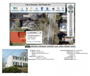 SiteVision and city officials worked closely together to integrate the existing system to the now enhanced version. Among improvements, existing web application servers migrated to the more feature-rich ESRI ArcGIS server and Adobe Flex environments. New features include floating, pull-down menus to permit rapid switching between various base maps. The redesigned site also includes Google Map and Google Street views. Comprehensive mapping and real estate information includes property overview, images, assessments, sales history, flooding information, community attributes and incentives. Users may also print a full property report including images.
 The Community and Incentive Website Portals, a useful feature previously developed in cooperation with SiteVision, has been incorporated into the enriched site. Community information provides users with a summary of specific neighborhood information including school zones, voter precincts, trash collection, parks and recreation, neighborhoods and libraries. The incentive portal provides a summary of city, state and federal incentive programs available to a specific parcel.
As a seasoned veteran in the geospatial sector, SiteVision has been planning, developing and hosting GIS Internet applications since the mid 1990’s. The firm’s experience ranges from evaluating, recommending, and designing local, regional, and state GIS applications and related infrastructures, to developing national systems designed to store and access multiple petabytes of geospatial Information.
SiteVision, Inc. (www.sitevision.com) is an Internet application development, consulting, design and hosting firm providing solutions for a broad spectrum of markets and industries, as well as for state, federal and international entities. Expertise includes custom, back-end dynamic applications, consulting to achieve unique goals, geographic information systems (GIS), content management systems, hosting services including, map and GIS application hosting, as well as custom and dedicated hosting solutions.
SiteVision, Inc. participates in, or is available through, the following state and federal contracting vehicles:
The firm has its home office in Roanoke, VA, with sales offices in Charlottesville, VA and Miami, FL.
XXX